Up to this point we have only concerned ourselves with lifting a single isolated parcel to determine the stability of a static layer in the atmosphere. While this might be appropriate for some of the convective clouds we observe, the atmosphere is not always so simplistic. Often, rather than a parcel of air, an entire layer is lifted. When air moves up a mountain side, the air above, as well as below, is lifted. Likewise, a layer of warmer air is also lifted over a cold front as it passes. When a layer of air is lifted its stability can be altered. Convective stability refers to the stability of a layer after it has been lifted. Ironically, a layer which initially appears stable, can become unstable very suddenly when the entire layer is lifted. A layer in the atmosphere which has this potential is called convectively unstable and often produces the more violent storms which result in large hail, damaging winds, and even tornadoes.
As a layer of air rises, depending on the distribution of moisture throughout the layer, the top and bottom portions of the layer may cool at different rates. If the lower portion of the layer contains more moisture than the upper portion, the lower boundary may reach its LCL first and begin cooling slower (according to the saturated adiabatic lapse rate)than the upper boundary. This causes an increase in the lapse rate throughout the lifted layer. If the lapse rate increases enough, the layer which was initially stable will become unstable.
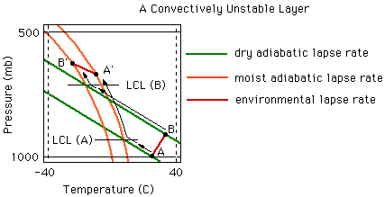
The diagram below illustrates how a stable layer may become unstable when lifted beyond the point of saturation. The initial lapse rate of the layer we will evaluate is represented by the red line that runs from A to B. Thus, this red line from A to B represents the temperature profile of the layer before it is lifted. The red line that connects points A' and B' represents the temperature profile of the layer after it has been lifted (at its new height). Initially, our layer is characterized by a temperature inversion, which indicates that it is extremely stable. As the layer is lifted, the lower boundary (A) reaches its LCL before the upper boundary (B). As a result, the lower portion of the layer begins to cool at a slower rate than the upper boundary. This difference in the rate of cooling between the upper and lower boundaries increases the lapse rate of the layer as it is lifted. (Note: A positive lapse rate is defined as a decrease in temperature with height. A temperature inversion has a negative lapse rate.) The layer, which initially had a negative lapse, has a positive lapse rate after it has been lifted. The temperature inversion has disappeared and B' is now colder than A. If we evaluate the stability of this layer after it has been lifted by comparing the new environmental lapse rate (A' to B') to the moist adiabatic lapse rate lines, we find that the lifted layer is unstable. The environmental lapse rate is greater than the moist adiabatic lapse rate, as we discussed in The Unstable Atmosphere. Although the layer from A to B was stable before it was lifted, it is considered convectively unstable.
A convectively unstable layer can also be defined by the change in the equivalent potential temperature
with height. In fact, the easiest way to determine the convective
stability of a layer is to compare the equivalent potential temperature of the upper and lower boundaries of the layer in question. We use this information to calculate the change in the equivalent potential
temperature ( e) with respect to height (z).
The change in the equivalent potential temperature through the layer gives us an indication of the moisture distribution in the layer. As we said earlier, a convectively unstable layer is characterized by a moist lower region and a dryer upper region. In a convectively unstable layer, the equivalent potential temperature of the lower boundary is greater than the upper boundary, or to say it another way, the equivalent potential temperature decreases with height through the layer. Similarly, in a convectively neutral layer there is no change in the potential temperature with height, while in a convectively stable layer, the potential temperature increases with height.
Convectively unstable conditions are often seen in the southern Great Plains of the US in the summer. Warm, moist air from the Gulf of Mexico resides near the surface while dry air from the west sits aloft. The transition between the two air masses is marked by a temperature inversion. Appropriate lifting of this convectively unstable layer can produce the violent storms we often associate with that region of the country.
 The Shodor
Education Foundation, Inc.