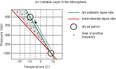
At times, in the atmosphere, a little push goes a long way. If a parcel of air is lifted and continues to rise after the lifting force disappears, the atmosphere is unstable. In an unstable layer, the lapse rate of a rising parcel is less than the lapse rate of the environment. Though the parcel cools as it rises, its temperature remains warmer than the surrounding air during its ascent through an unstable layer. Because the parcel is warmer than the environment, the parcel has positive buoyancy and continues to rise on its own.
In the diagram above, we have altered our atmospheric conditions slightly, once again, so that we may illustrate our dry air parcel rising through an unstable layer. In contrast with our previous examples, rather than lifting the parcel, we only need to give it a little push to get it going. Once the parcel gets just above the 1000 mb (100.0 kPa) pressure level, we find that the temperature of the parcel is actually warmer than the environment. Just as before, at 1000 mb (100.0 kPa) our parcel and the surrounding air are about 7 degrees Celsius. At 950 mb (95.0 kPa) the parcel has cooled to about 5 degrees Celsius but is 2 degrees warmer than the environment, and thus, has positive buoyancy. The parcel will rise on its own as long as it remains warmer than the surrounding air.
Follow this link to view a composite diagram and a brief review of the stable, neutral, and unstable layers (in a separate window).
Up to this point, to simplify these basic categories of stability, we have limited our examples to lifting a dry parcel. Rarely is the air in the atmosphere completely dry. Below, we have complicated matters a little by lifting a moist parcel through an unstable layer. We have used the same environmental lapse rate from above for easy comparison.
You may view a composite diagram (in a separate window) of the two diagrams above to easily compare the unstable layer for the moist and dry parcels.
Suppose that the LCL for the moist parcel in the diagram above was determined to be 925 mb (92.5 kPa). We are not given enough information to actually determine the LCL. Refer to Learning How to Read Adiabatic Charts (future link here) for a discussion on determining the LCL. As in the previous example, the parcel is lifted from 1000 mb (100.0 kPa) and an initial temperature of 7 degrees Celsius. It is initially unsaturated and cools according to the dry adiabatic lapse rate. At the LCL it is saturated and cools according to the moist adiabatic lapse rate. The diagram shows that the parcel is warmer than the surrounding air both above and below the LCL; thus, the entire layer illustrated by this diagram is categorized as unstable. As we have pointed out, in an unstable layer, the initial lifting force is only needed to get to the parcel going upwards. Immediately after the lifting begins, the parcel is buoyant and convection will continue on its own. Unstable environments are common in the afternoons during the summer and are often responsible for producing late afternoon thunderstorms.
Now that we have introduced you to the three basic categories of stability, let's take a look at a couple of more complex types of atmospheric instability: conditional instability and convective instability.
 The Shodor
Education Foundation, Inc.