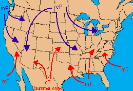
 An air mass is a very large body of air which has fairly uniform temperature and moisture properties throughout its horizontal extent, which may cover thousands of miles. Air masses originate in source regions, where the air is relatively stagnant and the air can acquire the properties of the source region. For example, the Canadian interior is a source region for the cold air that gives New England its first deep freeze in the autumn. An air mass that forms in the Bermuda region is what brings the Carolinas their hot, humid summers. There is a simple scheme of four classifications that are combined to describe an air mass's properties. A "c" stands for "continental", meaning that the air mass developed over land. An "m" stand for "maritime", meaning the air mass formed over water. A "P" stands for "polar", meaning the air formed over the cold polar regions. A "T" means the air mass formed over a warm "tropical" region. These four are combined to describe air masses according to the table below:
| Symbol | Classification | Description |
|---|---|---|
| cP | continental polar | cold, dry, stable |
| cT | continental tropical | hot, dry, stable air aloft; unstable air at surface |
| mP | maritime polar | cool, moist, unstable |
| mT | maritime tropical | warm, moist, unstable |
Air masses move from their source regions to the US and bring us their weather. The transition zone between two unlike air masses is called a frontal zone, which we discuss next.
 The Shodor
Education Foundation, Inc.