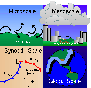
 Meteorologists classify weather phenomena into four classes or scales based on horizontal coverage and duration. The four scales are: microscale, mesoscale, synoptic scale, and global scale. As you move up each class from microscale, you lose detail of motion in the previous scale. For example, small turbulence in the branches of a tree cannot be seen when looking at the entire city, though you may still see the tree. And the thunderstorm over the city cannot be seen when looking at a weather map of the entire nation. Likewise, one cannot see the cold front over the mid-west when looking at jet stream patterns over the Northern Hemisphere. Each scale has its own phenomena, which contain the phenomena in the scale below it. We start with global scale.
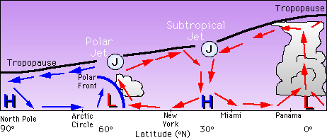
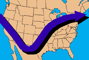
 Jet streams are high speed air currents found at the top of the troposphere, often with wind speeds in excess of 100 knots (115 mph). These air streams are ribbons of high speed winds which have lengths of thousands of miles, but are only a few hundred kilometers wide and only a few kilometers thick. Jet streams tend to follow sinusoidal motion as they move across the globe, carrying high pressure areas in their ridges and low pressure areas in their troughs, thus allowing the movement of cold fronts. Jet streams form in areas where the there is a break in the tropopause, allowing high winds to flow. There are two primary jet streams over the United States -- the subtropical jet stream and the polar jet stream. The subtropical jet stream forms around 30°N latitude, where a general high pressure area exists. The sinking air over this area marks the boundary between moist, hot air to the south and cooler air to the north. The steep temperature gradient leads to the formation of what is known as the subtropical front, and, therefore, the subtropical jet. The polar jet forms from a similar situation. Around 60°N latitude there exists a general low pressure area, marking the boundary between cold arctic air to the north and warmer air to the south. Again, a steep temperature gradient leads to the formation of a polar front and the polar jet stream.

Jet streams are important because they control the overall flow of air over the United States. Bends and turns in the jet streams show us where weather systems are and where they are going. For example, there exist within jet streams areas of maximum wind speed called jet streaks. The location of these lead to the intensification of storm systems. It is the low and high pressure systems that are guided by jet streams and strengthened by jet streaks that cause our everyday weather. We cover these systems next.
 The Shodor
Education Foundation, Inc.