We have discussed how aerosols are important to the formation of clouds, but how do clouds affect air quality?
Clouds affect air quality in many ways. First, they provide a reactive environment in which literally thousands of chemical reactions take place at any one time. Second, certain cloud types serve as transport and deposition mechanisms that can carry the pollutants away from the surface to great heights aloft or deposit them at the earth's surface through precipitation. Finally, clouds affect the radiation budget of the earth due to their ability to absorb and re-emit radiation. We will now look briefly at a couple of the prominent cloud types and how they function in each of these roles.

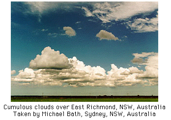
Cumulus and Cumulonimbus Clouds
Cumulus clouds are the white puffy clouds that we commonly see on sunny, summer afternoons and are most often the type that form during the passage of cold fronts. Cumulus clouds are non-precipitating but can develop into the towering cumulonimbus clouds which produce heavy downpours and strong winds. These clouds are characterized by very strong updrafts, and they develop very rapidly, rising high into the troposphere. However, more often than not, cumulus clouds dissipate as quickly as they form. Due to their short life spans, they provide a moist chemically reactive environment for a short period of time. This allows reactions to take place before droplets evaporate leaving behind newly formed compounds to linger and react once again. An example of this is the oxides of sulfur which react to form sulfates. Over the course of a summer afternoon, you may notice a haze developing. This is often the result of the concentration of sulfates increasing as cumulus clouds form and evaporate.
Cumulus and cumulonimbus clouds are good absorbers of long wave radiation emitted by the earth. They can, because of their thickness and larger water droplets, also reflect a lot of sunlight away from the earth. But, because they are generally scattered and do not blanket large areas , they do not have as much of an influence on the earth's heat budget as the next group, the stratus clouds.

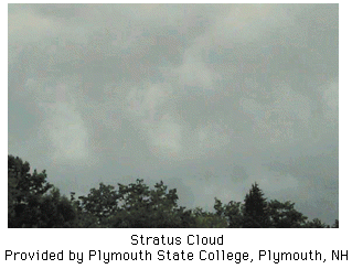
Stratus and Nimbostratus Clouds
The stratus clouds are layer clouds and are more common in the winter prior to the passage of warm fronts. They are also common in winter over large bodies of water after a cold front passage. These clouds blanket the sky over a large region, and unlike cumulus clouds, do not have a defined shape. As an example, fog is a stratus cloud that forms at or near the surface. Stratus clouds aloft form slowly by gradual lifting as opposed to the turbulent convection of cumulus clouds. As a result, the cloud droplets form more slowly and are generally smaller and more numerous than the cloud droplets of a cumulus cloud. Stratus clouds are also non-precipitating. The nimbostratus, somewhat analogous to the cumulonimbus, is a layer cloud that does produce precipitation. This is the cloud that we associate with the continuous rains and snows we receive in the winters, in contrast with the very temporary heavy downpours we may experience on summer afternoons from the cumulonimbus cloud.
These layer clouds can persist for days, making for a moist, chemically active atmosphere. In addition, they are not associated with good vertical mixing of pollutants since their low tops usually mark a capping, frontal inversion. Rather, pollutant emissions are restricted within a relatively low mixing layer where we can be exposed to higher concentrations. Because nimbostratus clouds are associated with extended periods of precipitation, they are effective at cleansing the atmosphere.
Stratus clouds play a major role in the heat budget of the earth. Not only do they reflect much of the suns radiation away from the earth, they absorb much of the long wave radiation emitted by the earth. The net result is cooler days and warmer nights, reducing the differential heating of earth between night and day.
(More cloud photographs can be accessed on-line at Michael Bath and Jimmy Deguara's Weather Photography Library and the Plymouth State College Meteorology Program Cloud Boutique.)
 The Shodor
Education Foundation, Inc.