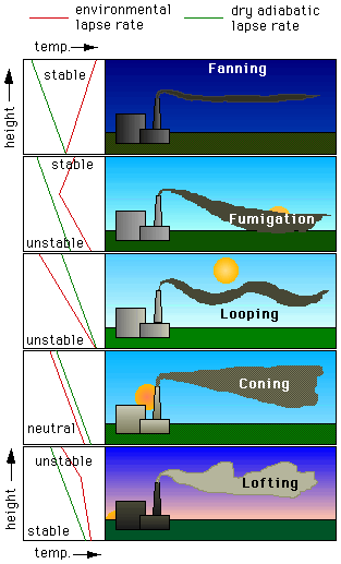

Consider the illustrations on the left. The stability of the atmosphere often dictates the behavior of a plume in terms of the height it will rise and to what degree it will mix into the environment. For example, a plume released into an unstable atmosphere will display a looping pattern. Looping occurs when updrafts from warming air at the surface carry a segment of the plume upward while compensating downdrafts force the adjacent section downward. Coning occurs when a plume is released in the middle of a neutral layer. In addition to early evening, as the graphic illustrates, coning is common on over cast days and at night with the presence of strong winds. A stable atmosphere, commonly marked by an inversion on clear nights, yields a fanning pattern. A plume released into a stable atmosphere will not rise or mix unless it encounters turbulence. A fanning plume will often extend long distances down wind from the source.
Looping, coning, and fanning are characteristic of the more persistent conditions of stability, and for this reason, are observed for longer durations over a 24 - hour day. Fumigation and lofting, however, frequently characterize the transition periods between day and night and seldom last for more than a couple of hours. Fumigation occurs in the morning hours as the nighttime inversion gradually disappears due to surface heating. As the surface heats, the air just above it warms. An unstable layer builds from the surface upward but remains capped by the inversion above. A plume released beneath the inversion is trapped near the surface until the inversion eventually disappears and is replaced by an unstable layer. Conversely, lofting occurs in the evening as soon as surface heating ceases and radiational cooling begins.
In addition to predicting the transport and dispersion of pollutants based on the the wind direction, together with the stability of the atmosphere, meteorologists can predict when certain conditions are more likely to occur and how long they might persist. Surface based temperature inversions are very common - from before sunset to after sunrise - unless there is considerable cloud cover or strong winds. As the sun rises and heats the surface, the inversion layer is eliminated from below and the air becomes unstable as the warm air rises and mixes. The looping plume that is characteristic of a turbulent, unstable layer can cause high ground level concentrations, but the wind speeds are usually low and the wind direction quite variable so the parts of the plume that reach the ground are shortlived and spread over a wide area around the stack.
If we know when certain conditions of stability are most likely to occur and what effect they have on the transport, dispersion, and deposition of pollutants, we can more easily determine when and to what extent emissions should be restricted. City planners and developers can take advantage of this knowledge in order to determine appropriate locations for commercial and residential zoning.
 The
Shodor
Education Foundation, Inc.