Cyclones and Anticyclones
Cyclones
A cyclone is any low pressure system that spins counter-clockwise (in the Southern Hemisphere it spins clockwise). Cyclones range in size from tiny whirlwinds to thunderstorms to hurricanes. There are two types of cyclones which we will discuss in this section: mid-latitude cyclones and tropical cyclones.
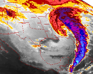
Low pressure cyclones that form outside of tropical regions are known as extratropical cyclones or mid-latitude cyclones. These are the weather systems that bring us snow storms in the winter and lines of severe thunderstorms in the summer. The cyclones are usually associated with frontal zones, separating the moist air ahead of the cyclone from the dry air behind the cyclone.
Air spirals counter-clockwise at the surface into a cyclone. The air is then forced upward by convergence. This rising air is what leads to the clouds and storms associated with the cyclone. The image above is of the mid-latitude cyclone of March 11-13, 1993, which is sometimes called "The Storm of the Century". Notice the comma shape of the cloud band. A comma shape is typical of very strong mid-latitude cyclones.
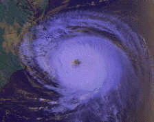
Tropical cyclones are those which form in tropical areas. These start off as tropical depressions, then grow into tropical storms, and may eventually strengthen into hurricanes. Unlike mid-latitude cyclones, tropical cyclones are not associated with fronts. They are self-contained and intensify due to moisture and wind convergence. The picture to the right is of Hurricane Emily hitting the coast of North Carolina. You can see the counter-clockwise motion and a clear area in the center of the storm. This is called the eye of the storm. The eye is an area of intense low pressure with clear skies. Storm intensity is sometimes measured by how well-defined the eye is and how wide the eye is. Generally, the more intense the storm, the more well defined and narrow the eye of the hurricane. Another frequently used system for measuring hurricane intensity is based on potential storm damage. Damage estimates are classified on a numerical scale from one to five, with five being the most intense hurricane.
The opposite of a cyclone is an anticyclone. It is a high pressure system with winds that blow out from the center of the high in a clockwise direction. High pressure systems usually bring dry, clear weather. In anticyclones, the air converges high in the atmosphere and then sinks toward the ground. In the lower atmosphere, the air spreads out, or diverges. The sinking air contains little moisture, and therefore brings dry weather.
Air masses in general and, more specifically, fronts, cyclones, and anticyclones are examples of synoptic scale weather systems. The scale below synoptic is mesoscale, which we discuss next.


Developed by
 The Shodor
Education Foundation, Inc.
Copyright © 1996


 The Shodor
Education Foundation, Inc.