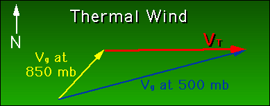

The thermal wind is expressed simply as the geostrophic wind for the upper level minus the geostrophic wind for the lower level. Remember, pressure decreases as you go up, so in our example, the upper Vg is at the 500 mb (50 kPa) level, and the lower at the 850 mb (85 kPa) level.
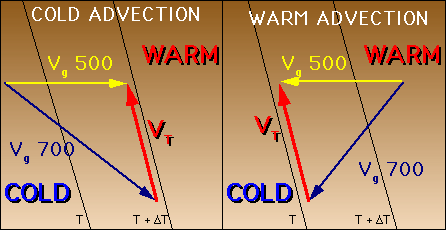
What is the significance of the thermal wind? It is a good way of showing temperature advection. Remember, advection is horizontal temperature transfer. Geostrophic wind has higher pressure values to the right of the direction of Vg and lower pressure values on the left. Similarly, the thermal wind has higher values to the right of the direction of VT and lower values on the left, only in this case the values are temperature, not pressure. Therefore it is possible to determine whether cold or warm advection is occurring.

Notice above that in the case of cold advection, the geostrophic wind backs with height, i.e its direction shifts counter-clockwise. For warm advection, the wind veers with height, or shifts clockwise. Logically, a large thermal wind means there is a tight thermal gradient, the best examples of which occur at a frontal zone.
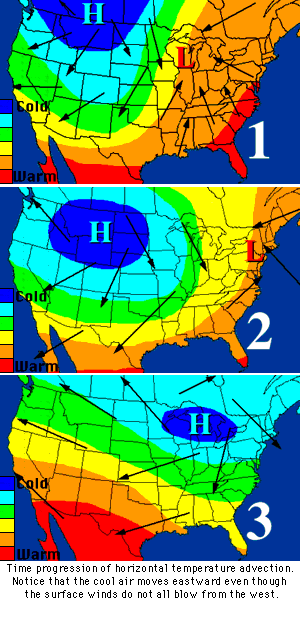
 Like the geostrophic wind, the thermal wind is completely theoretical. In fact, it isn't even a wind as most would think of wind, i.e. moving air. The thermal wind is only the vector used to determine temperature advection from the change in the geostrophic wind. The other thing to keep in mind is that shifts in air flow are not necessarily connected to changes in temperature. Take, for example, the wind flow around a high pressure system. To the east of the high pressure center, the winds are approximately from the north. However, the system as a whole is moving toward the east. Will the 60°F temperature line move toward the south (following the wind flow) or toward the east (following the system movement)? The 60°F isotherm (line of constant temperature) will tend to move with the system, not necessarily with the wind flow. Notice in the pictures to the left that the cold air shifts to the east, while the wind circulates around the the low and high pressure centers. The winds, in this case, do not blow the cold air east. There are other factors involved (which we will not get into), but it is important to realize that actual wind flow is not necessarily connected to temperature advection.
 The Shodor
Education Foundation, Inc.