Temperature
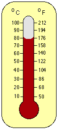
 When we hear the word "temperature" we normally think of hot and cold. But what is hot and cold? When we measure the temperature of something we are actually measuring the average kinetic energy of molecules. Therefore, when we measure the air temperature, we are measuring the average kinetic energy of the molecules that make up the composition of the air. When air molecules bombard a thermometer, the kinetic energy of the air molecules is transferred to the liquid in the thermometer. This transfer of energy causes the liquid to heat up and expand and the thermometer to "rise." In the upper layer of the atmosphere, the thermosphere, the temperature is very hot, at 115 km it can be as hot as 65 C, but you would freeze because there are so few molecules that high up to bombard your body.
In meteorology we usually record temperatures in degrees centigrade or Celsius (C), but for computations we convert degrees Celsius to degrees Kelvin (K). (Use the temperature converter below to convert between degrees Fahrenheit, Celsius, and Kelvin.) Water freezes at 0 C and boils at 100 C. The centigrade temperature scale was, in fact, derived from these properties of water to create a scale with convenient reference points. The Kelvin scale is referred to as the absolute temperature scale. Zero degrees Kelvin (0 K) is absolute zero. If a substance has a temperature of 0 K then this means that all molecular motion has ceased. The molecules have no motion, thus no kinetic energy, and absolutely no temperature. Zero degrees Kelvin converts to centigrade as -273 C. In fact, this easy conversion is another reason we use the Celsius and the Kelvin scales. All you have to do to convert units of Celsius to Kelvin is add 273 degress to the centigrade temperature.
As in the case of the thermometer, increased molecular motion of the air molecules results in the expansion of the air. In other words, as the speed of the molecules increases, the molecules spread further away from each other making the air less dense. As mentioned earlier in this course, the "normal" density of air is 1.2 kg/m3. Less dense or lighter materials "float" on denser materials like a cork floats on the water. This is the reason warm air rises. Convection in the atmosphere is caused by heating of the air nearer the heat source, usually the ground, pavement, or a body of water. The heat is transferred to the air, causing it to expand and rise. Convection is one way in which pollutants are transported away from the surface of the earth and diluted with cleaner air.
On to Moisture
Back to Why We Measure the Atmosphere
 The Shodor
Education Foundation, Inc.
The Shodor
Education Foundation, Inc.Copyright © 1996