Remote Sensing Techniques
In the last few sections we have said much about the direct measurements we make of the atmosphere and some of the additional parameters we determine from them. However, over the last decade meteorologists and air quality specialists have relied greatly on remote sensing devices such as radar and satellite to supplement the data acquired by the more traditional forms of measurement such as radiosonde launches. This technology enables them to make more frequent and often more detailed measurements of our atmosphere. Remote sensing also proves to be more cost effective than the traditional methods of direct measurements. At this point, remote sensing techniques cannot replace the older methods, but they do supplement traditional methods by providing additional data that cannot be retrieved by other means. In the remaining sections of this session we provide a brief look at a few remote sensing devices and how they are used for meteorological and air quality purposes.
Ground Based Remote Sensing Devices
Whether we realize it or not, most of us are familiar with and share a sense of dependence on remote sensing techniques. What is the last thing many of us just have to do before we go to bed at night or leave for work in the morning? We simply cannot get up from the couch or the breakfast table without watching the weather forecast to see the most current Doppler radar image. With this image, we can see where precipitation is falling, the intensity of the precipitation, how fast a system is moving our way, or how long a system may hang over us to ruin any outdoor plans we might have made. The radar image has won us over to the incredible capabilities and convenience of remote sensing.
Radar was first developed in World War II to detect enemy ships and planes. Radar worked well in good weather, but in bad weather the enemy could often go undetected due to interference in the signal which clouded the radar screen. Researchers and developers found that this interference was a result of a reflection of the electromagnetic signal, or back scatter, by the moisture in the atmosphere, more specifically, cloud water droplets. Radar systems now can interpret the backscatter from these droplets to determine where and how much precipitation is falling. The radar images we see during weather broadcasts are designed to have a horizontal range in excess of 100 km. There are also profiling radars that have no horizontal range, rather, they are designed for use only in the vertical direction, much like a radiosonde. These profilers can construct vertical temperature, moisture, and wind profiles in great detail up to 3 km.
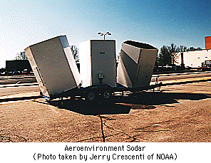
 RADAR, which stands for Radio Detection and Ranging is only one of several ground based remote sensing profiling techniques in use today. Ground based devices are categorized by the wavelength of the electromagnetic signal they emit. Radars emit a signal in the radio frequency while SODARS, Sound Detection and Ranging devices, emit signal in the audible spectrum. Likewise, LIDAR devices, which stands for Light Detection and Ranging, emit signal of visible wavelengths. A fourth device known as a RASS, which conveniently stands for Radio-Acoustic Sounding System, combines the radar and sodar technologies. Each of these devices emits an electromagnetic pulse which is reflected back to the device when it encounters obstructions or interference. By knowing the frequency of the pulse emitted, how fast it travels, and how quickly it returns, the distance of the obstruction can be determined as well as properties of the obstruction. For meteorological and air quality purposes, the obstruction targeted is often moisture, wind, temperature variations, and aerosols.

These ground based profilers use the backscatter of the signal they emit to construct wind, temperature, and moisture profiles. The detail of information they can provide and the convenience and frequency in which they can generate data help meteorologists to better predict factors important to air quality such as the vertical mixing height, stability, and wind patterns of the atmosphere. These factors pretty much determine when, where, and how fast pollutants will be transported and diluted by mixing.


Developed by
 The Shodor
Education Foundation, Inc.
Copyright © 1996
 RADAR, which stands for Radio Detection and Ranging is only one of several ground based remote sensing profiling techniques in use today. Ground based devices are categorized by the wavelength of the electromagnetic signal they emit. Radars emit a signal in the radio frequency while SODARS, Sound Detection and Ranging devices, emit signal in the audible spectrum. Likewise, LIDAR devices, which stands for Light Detection and Ranging, emit signal of visible wavelengths. A fourth device known as a RASS, which conveniently stands for Radio-Acoustic Sounding System, combines the radar and sodar technologies. Each of these devices emits an electromagnetic pulse which is reflected back to the device when it encounters obstructions or interference. By knowing the frequency of the pulse emitted, how fast it travels, and how quickly it returns, the distance of the obstruction can be determined as well as properties of the obstruction. For meteorological and air quality purposes, the obstruction targeted is often moisture, wind, temperature variations, and aerosols.
 The Shodor
Education Foundation, Inc.